


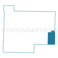
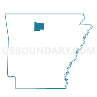
Oxley Voting District, Searcy County, Arkansas
About
Outline

Summary
| Unique Area Identifier | 528115 |
| Name | Oxley Voting District |
| County | Searcy County |
| State | Arkansas |
| Area (square miles) | 30.04 |
| Land Area (square miles) | 30.02 |
| Water Area (square miles) | 0.03 |
| % of Land Area | 99.92 |
| % of Water Area | 0.08 |
| Latitude of the Internal Point | 35.84149790 |
| Longtitude of the Internal Point | -92.45094850 |
Maps

Graphs
Select a template below for downloading or customizing gragh for Oxley Voting District, Searcy County, Arkansas


Neighbors
Neighoring Voting District (by Name) Neighboring Voting District on the Map
- Flag Voting District, Stone County, AR
- Linn Creek Voting District, Van Buren County, AR
- Locust Grove Voting District, Stone County, AR
- Long Creek Voting District, Searcy County, AR
- Washington Voting District, Van Buren County, AR
- Wiley Cove Voting District, Searcy County, AR
Top 10 Neighboring County Subdivision (by Population) Neighboring County Subdivision on the Map
- Washington township, Van Buren County, AR (850)
- Wileys Cove township, Searcy County, AR (777)
- Linn Creek township, Van Buren County, AR (655)
- Long Creek township, Searcy County, AR (474)
- Oxley township, Searcy County, AR (364)
- Locust Grove township, Stone County, AR (166)
- Flag township, Stone County, AR (152)
Top 10 Neighboring Place (by Population) Neighboring Place on the Map
Top 10 Neighboring Unified School District (by Population) Neighboring Unified School District on the Map
- Mountain View School District, AR (12,192)
- Clinton School District, AR (9,129)
- Searcy County School District, AR (6,747)
- Shirley School District, AR (4,501)
Top 10 Neighboring State Legislative District Lower Chamber (by Population) Neighboring State Legislative District Lower Chamber on the Map
- State House District 70, AR (29,754)
- State House District 86, AR (28,614)
- State House District 71, AR (26,638)
Top 10 Neighboring State Legislative District Upper Chamber (by Population) Neighboring State Legislative District Upper Chamber on the Map
- State Senate District 18, AR (85,656)
- State Senate District 2, AR (83,273)
- State Senate District 10, AR (80,214)
Top 10 Neighboring 111th Congressional District (by Population) Neighboring 111th Congressional District on the Map
Top 10 Neighboring Census Tract (by Population) Neighboring Census Tract on the Map
- Census Tract 9501, Stone County, AR (4,003)
- Census Tract 4601, Van Buren County, AR (3,552)
- Census Tract 9703, Searcy County, AR (2,225)